
C-MAP - 4D MAX + WIDE - West European Coasts - μSD / SD card

€212.90*
% €236.81* (10.1% saved vs. recommended price)16 in stock
Available, delivery time: 1-3 business days
Product number:
1971968
EAN:
8053800670258
Manufacturer product ID:
M-EW-D228-MS
Please note that our English product descriptions are automatic translations from German. If anything is unclear, please contact us and/or double check the description by the manufacturer. Thanks for your understanding! - your Klabauter Crew
Product information "C-MAP - 4D MAX + WIDE - West European Coasts - μSD / SD card"
C-MAP cartography
Over the past 30 years, their confidence in the electronic charts of C-MAP have set over one million seafarers. The vector-based maps of C-MAP provide unique navigation details and are compatible with many plotters known brands as well as PC-based navigation software.
Our exclusive navigation features and value-added data to make the solutions of C-MAP irreplaceable.
The C-MAP charts are programmed to order in our house, you get to receive the latest information for your trading area.
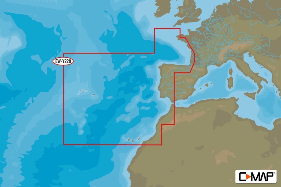
In addition to the coverage areas shown we of course offer the complete C-MAP product range and, of course, update or upgrade your existing C-MAP products.
The current C-MAP catalog and a compatibility list can be found on our website under "Product information" for download.
Under the product name C-MAP different card products offered on different disks.
Please make absolutely sure that the ordered product cards with your device is compatible!
C-MAP 4D MAX + is combined the latest development of electronic navigation technology, the award-winning vector map data with exclusive Dynamic raster charts, plus the ability to map is shown in 2D or 3D presentation with amazing high-resolution satellite images. Full of innovative features that are designed to improve every boat, fishing or sailing experience.
Compatible with top plotter manufacturers including Furuno, Humminbird, Raymarine and Standard Horizon
Local and wide coverage available worldwide and a budget that is suitable for your needs Boating
Ability to add future value-added data segments and functions
Over the past 30 years, their confidence in the electronic charts of C-MAP have set over one million seafarers. The vector-based maps of C-MAP provide unique navigation details and are compatible with many plotters known brands as well as PC-based navigation software.
Our exclusive navigation features and value-added data to make the solutions of C-MAP irreplaceable.
The C-MAP charts are programmed to order in our house, you get to receive the latest information for your trading area.
In addition to the coverage areas shown we of course offer the complete C-MAP product range and, of course, update or upgrade your existing C-MAP products.
The current C-MAP catalog and a compatibility list can be found on our website under "Product information" for download.
Under the product name C-MAP different card products offered on different disks.
Please make absolutely sure that the ordered product cards with your device is compatible!
C-MAP 4D MAX + is combined the latest development of electronic navigation technology, the award-winning vector map data with exclusive Dynamic raster charts, plus the ability to map is shown in 2D or 3D presentation with amazing high-resolution satellite images. Full of innovative features that are designed to improve every boat, fishing or sailing experience.
Compatible with top plotter manufacturers including Furuno, Humminbird, Raymarine and Standard Horizon
Local and wide coverage available worldwide and a budget that is suitable for your needs Boating
Ability to add future value-added data segments and functions